

-
-
A Review on How Education Shapes Population Structure and Climate Risks
교육이 인구구조와 기후 리스크에 미치는 영향에 관한 고찰
-
Kwak, Minhee · Kim, Oh Seok
곽민희 · 김오석
- This study proposes a conceptual lens that enables a comprehensive analysis of climate risks within the context of “education-population structure-climate change” dynamics …
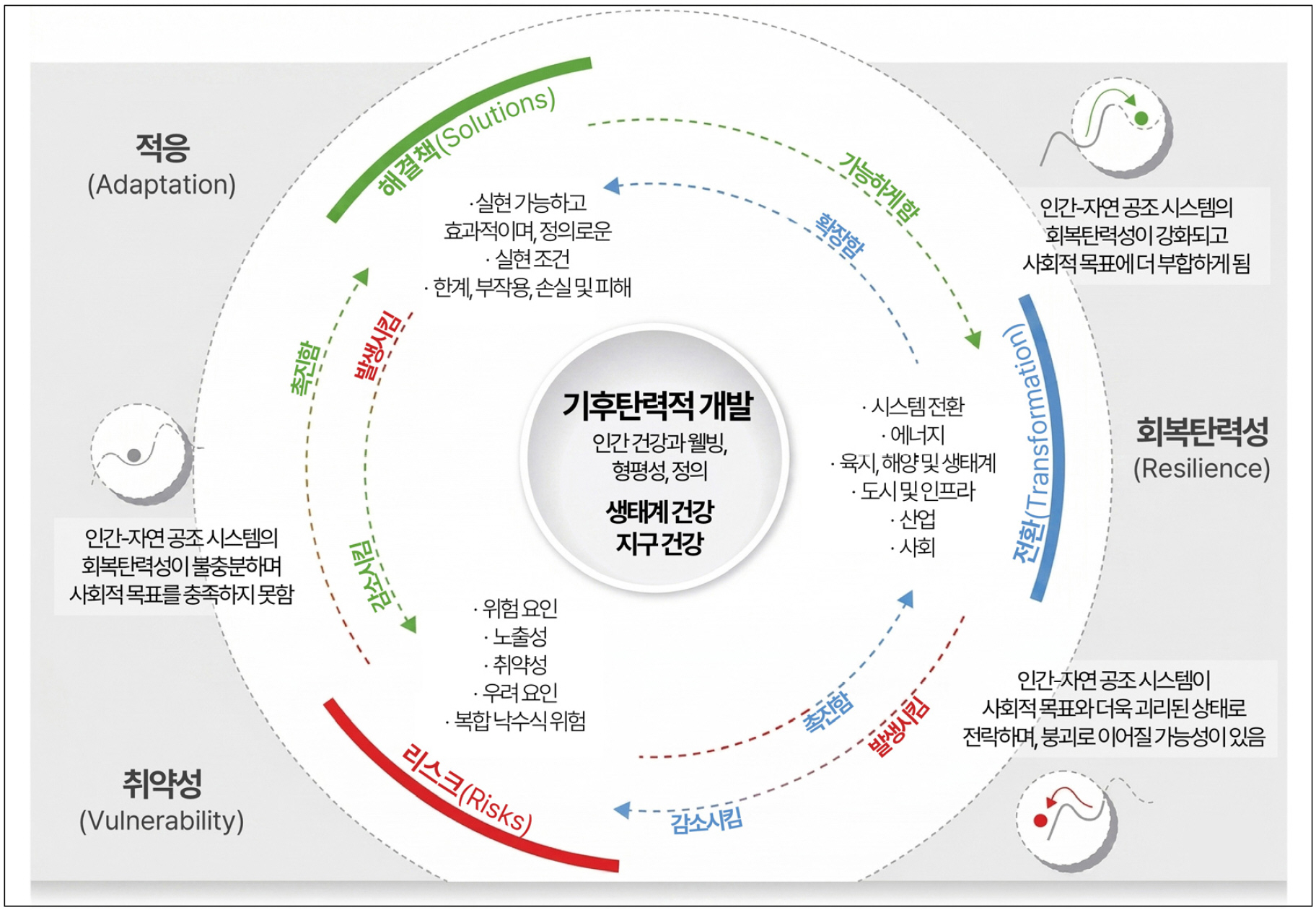
본 연구는 기후변화에 관한 정부간 협의체(Intergovernmental Panel on Climate Change, IPCC)의 리스크 프레임워크를 구성하는 핵심 요소 가운데 취약성 개념에 기반하여, ‘교육-인구구조-기후변화’의 상호작용적 …
- This study proposes a conceptual lens that enables a comprehensive analysis of climate risks within the context of “education-population structure-climate change” dynamics based on vulnerability, a core element of the IPCC’s risk framework. To this end, we conducted a narrative review of 82 publications across three thematic areas covering education and population structure, population structure and climate change, and education and climate change. Education is not merely a socioeconomic explanatory variable but a key factor influencing fertility and mortality as well as accumulation of human capital, thereby supporting a transition from quantitative to qualitative population growth. This transition is presented as a potential long-term structural pathway linking changes in population structure to climate change vulnerability and adaptive capacity. Furthermore, the pathway exhibits spatial heterogeneity, operating unevenly depending on local socioeconomic contexts. This study is significant in that it examines the relationships among education, population structure, and climate change not as a linear causal chain but as a long-term, structural interaction, thereby offering a dynamic perspective for addressing climate risk.
- COLLAPSE
본 연구는 기후변화에 관한 정부간 협의체(Intergovernmental Panel on Climate Change, IPCC)의 리스크 프레임워크를 구성하는 핵심 요소 가운데 취약성 개념에 기반하여, ‘교육-인구구조-기후변화’의 상호작용적 맥락을 통합적으로 바라볼 수 있는 개념적 틀을 제안하였다. 이를 위해 서사적 문헌 고찰을 통해 교육과 인구구조, 인구구조와 기후변화, 교육과 기후변화의 세 주제 영역에 걸쳐 총 82편의 문헌을 검토하였다. 교육은 단순한 사회경제적 설명 변수가 아닌 인구의 출산율과 사망률, 인적자본의 축적 등에 영향을 미치는 핵심 요인으로, 인구의 ‘양적 성장에서 질적 성장으로의 전환’을 설명하는 핵심 기제로 논의된다. 이러한 과정은 인구구조의 변화를 통해 기후변화 취약성과 적응역량에 장기적으로 구조적 영향을 미칠 수 있는 잠재적 경로로 제시된다. 또한 이와 같은 관계는 공간적으로 균질하게 나타나지 않고, 지역의 사회경제적 맥락에 따라 불균등하게 작동한다. 본 연구는 교육-인구구조-기후변화 간의 관계를 단선적인 인과가 아닌 장기적·구조적 상호작용의 관점에서 통합적으로 검토하였다는 점에서 의의를 가지며, 기후 리스크 대응을 위한 동태적 분석 틀을 제공한다.
-
A Review on How Education Shapes Population Structure and Climate Risks
-
-
Comparison of LSTM-Based Models for Small-Area Household Projections in the Seoul Metropolitan Area
- Applicability of Infrastructure Factors and Spatial Dependency -
수도권 소지역 가구추계를 위한 LSTM 기반 모델 비교 - 인프라 요인과 공간적 의존성의 적용 가능성 -
-
Mun, Sohyun
문소현
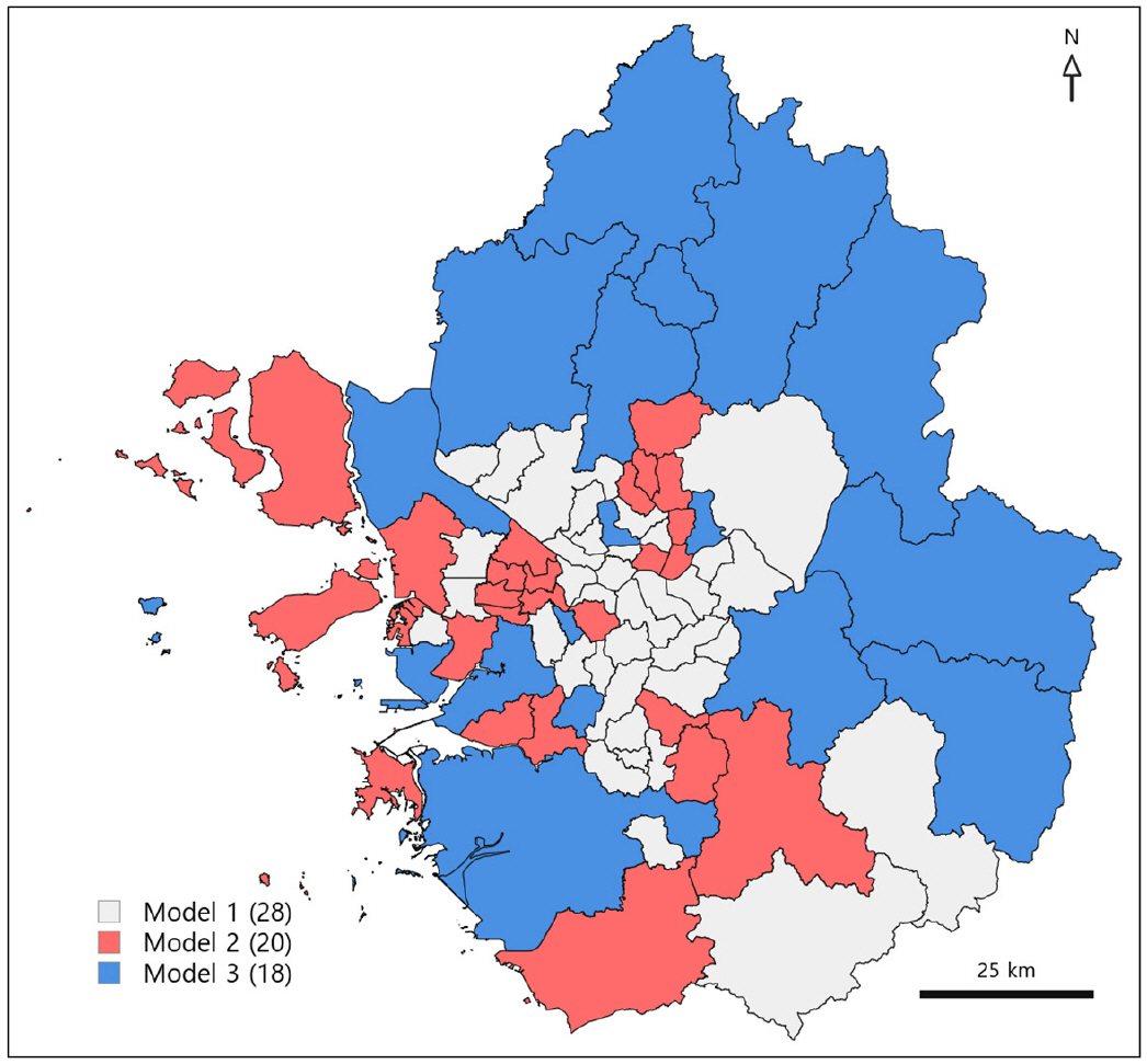
- This study examined the applicability of LSTM-based models for small-area future household projections across 66 cities in the Seoul Metropolitan Area (SMA), …
본 연구는 수도권 66개 시군구를 대상으로 소지역 장래가구추계에서 LSTM 기반 모델의 적용 가능성과 입력 변수 구성에 따른 예측 성능 차이를 검토하였다. 모델은 …
- This study examined the applicability of LSTM-based models for small-area future household projections across 66 cities in the Seoul Metropolitan Area (SMA), focusing on differences in predictive performance by input variable configuration. Three models were constructed based on the past trend of the number of households (Model 1), adding infrastructure factors (Model 2), and adding spatial lag factors (Model 3). The evaluation showed that Model 2 generally produced lower MAPE and MdAPE values, but the model with the lowest error differed by region and household type. By household type, Model 2 showed lower errors for one and two person households headed by householders in their 20s or younger and 30s, whereas Model 3 showed lower errors for households headed by householders in their 40s or 50s. These findings suggest that small-area household projections may need to consider region and household-specific input variable configurations, and that future research may extend this approach through ensemble models.
- COLLAPSE
본 연구는 수도권 66개 시군구를 대상으로 소지역 장래가구추계에서 LSTM 기반 모델의 적용 가능성과 입력 변수 구성에 따른 예측 성능 차이를 검토하였다. 모델은 과거 가구 수 추세 기반(모델 1), 인프라 요인 추가(모델 2), 공간 래그 요인 추가(모델 3) 세 가지로 구축하였다. 성능 평가 결과, 모델 2의 MAPE와 MdAPE가 전반적으로 낮았으나, 지역별·가구 유형별로 낮은 오차를 보이는 모델 구성은 상이하였다. 가구 유형별로는 20대 이하·30대 1·2인 가구에서 모델 2, 40-50대 가구에서 모델 3의 오차가 낮게 나타나 지역 및 가구 특성에 따라 적절한 입력 변수 구성이 달라질 수 있음을 확인하였다. 본 연구는 제한된 소지역 자료 조건 내에서 LSTM 기반 가구추계 모델의 적용 가능성을 검토하고, 지역 및 가구 특성에 따른 앙상블 모델 개발 방향을 제시하였다.
-
Comparison of LSTM-Based Models for Small-Area Household Projections in the Seoul Metropolitan Area
- Applicability of Infrastructure Factors and Spatial Dependency -
-
-
The Administrative Territorial Structure of France
- The Cumulative Stratification of Administrative Space -
프랑스의 행정 영토 구조 - 행정 공간의 누적적 중층화 -
-
Kim, Jisun · Ahn, Young-Jin
김지선 · 안영진
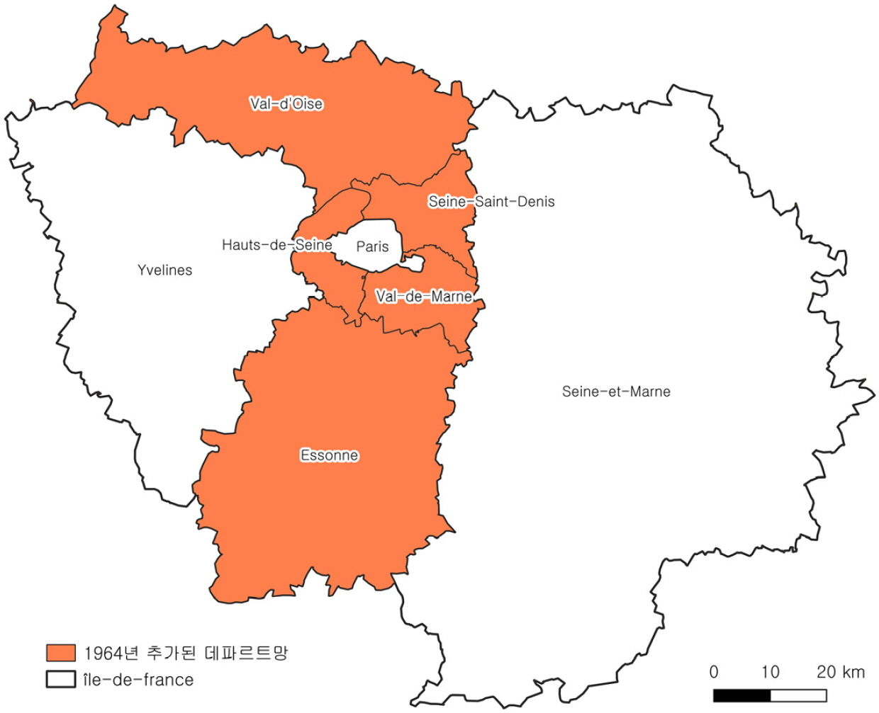
- The structure of administrative territories in France is referred to as the “Millefeuille Territory”. This study examines the processes of formation and …
프랑스에서는 여러 층의 행정 공간으로 이루어진 영토 구조를 ‘밀푀유 영토’라고 부른다. 본 연구는 프랑스의 근대적 행정구역 형성 시기인 1789년부터 각 행정 계층인 …
- The structure of administrative territories in France is referred to as the “Millefeuille Territory”. This study examines the processes of formation and change of each administrative district level-such as commune, intercommunality, department, and region-from 1789 when the modern administrative division of France was established, and analyzes the reasons why these layers accumulated over time. As a result the basic State-Department-Commune, which constituted the cornerstone of administrative territory, persists, and the Region was added in the 1980s. Moreover, the intercommunality, especially the Metropole, as a modern governance system between the communes and the departments further complicates the administrative territorial structure. Thus, the case of France shows that changes resulting from the administrative district mergers can also affect the structure of the administrative territory, with implications for South Korea.
- COLLAPSE
프랑스에서는 여러 층의 행정 공간으로 이루어진 영토 구조를 ‘밀푀유 영토’라고 부른다. 본 연구는 프랑스의 근대적 행정구역 형성 시기인 1789년부터 각 행정 계층인 코뮌, 코뮌 연합체, 데파르트망, 레지옹 등의 형성 및 변화 과정을 살펴보며, 밀푀유 영토가 왜 형성되었는지를 분석하고자 하였다. 연구 결과, 기존의 국가-데파르트망-코뮌으로 이루어졌던 기본적 행정구역 체계에 1980년대 레지옹이 신설되었고, 코뮌과 데파르트망 행정구역에 코뮌 연합기관과 그에 속한 메트로폴이 현대적 거버넌스 행정구역 체계로 추가되면서 프랑스의 행정 영토 체계가 복잡해지는 양상을 확인할 수 있었다. 이러한 프랑스의 사례는 최근 한국에서 진행되고 있는 행정구역 통폐합으로 인한 변화가 국가행정 영토 구조와 특성에 어떤 영향을 미칠 것인지에 대한 적잖은 시사점을 제공한다.
-
The Administrative Territorial Structure of France
- The Cumulative Stratification of Administrative Space -
-
-
The Paradox of the View
- Landscape Homogenization and the Dilemma of Café-Led Regeneration in Yeongdo-gu, Busan -
뷰의 역설 - 영도구 카페 경관의 동질화와 카페 주도 재생의 딜레마 -
-
Park, Jieun · Lee, Jong-Ho
박지은 · 이종호
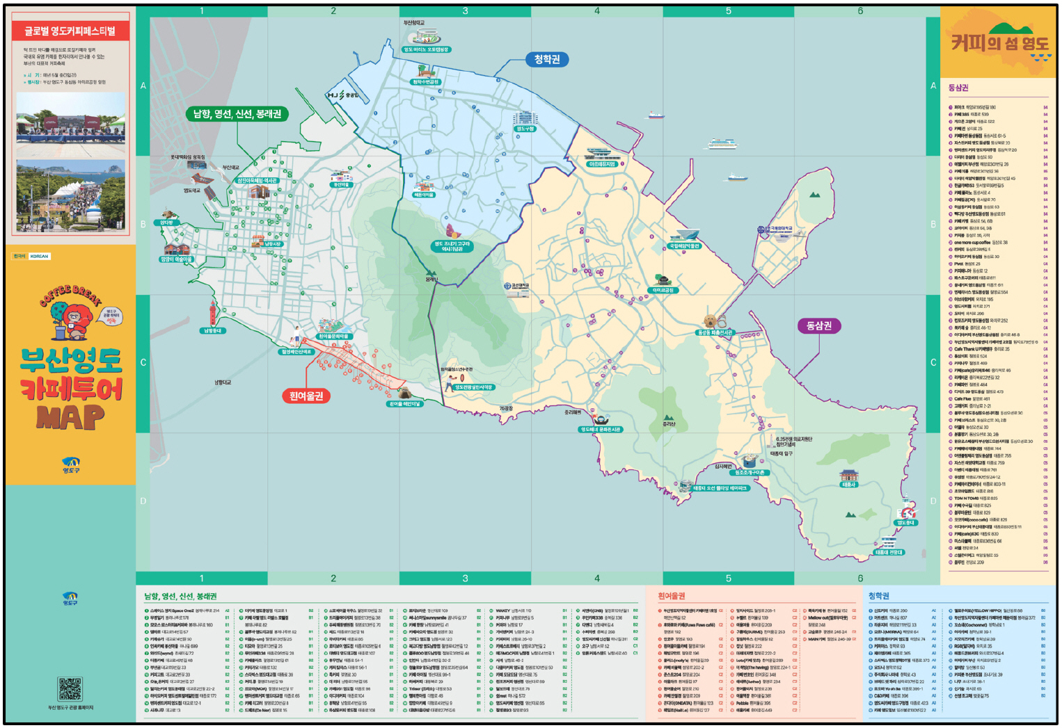
- In Yeongdo-gu, Busan—a region facing the risk of local extinction due to demographic and industrial decline—a rapid “café boom” has been observed …
인구와 산업의 침체로 소멸 위기에 직면한 부산 영도구는 2020년대 초반부터 급격한 ‘카페 붐’이 일고 있다. 본 연구는 이러한 카페 붐의 동학을 분석하며, …
- In Yeongdo-gu, Busan—a region facing the risk of local extinction due to demographic and industrial decline—a rapid “café boom” has been observed since the early 2020s. This study analyzes the dynamics of this café boom, conceptualizing it as “the paradox of the view” by focusing on how the core asset that catalyzed the boom ironically acts as a shackle threatening spatial sustainability. Methodologically, this study employs in-depth interviews with café operators—selected to reflect diverse business histories, scales, and operational models—as primary data, supplemented by interviews with visitors and policymakers. The analysis reveals that the core asset of Yeongdo’s café landscape is a shared landscape resource characterized as a “dynamic view” in which harbors, ships, and bridges converge. However, as all cafés equally appropriate this resource, the landscape has converged toward an upwardly standardized homogenization. The resulting competition to scale up to overcome this homogeneity has led to the exclusion of small-scale independent cafés lacking capital power. Whether industrial heritage is merely consumed as a backdrop or recreated as unique brand equity, and whether “view dependency” can be overcome, are unevenly distributed depending on capital scale; furthermore, local government policies focused on physical landscape improvement have exacerbated these dynamics. Ultimately, while Yeongdo’s café boom grew on the basis of shared landscape assets, its over-appropriation is paradoxically undermining its own foundation. This contradiction raises fundamental critical questions about the dominant perspective that consumes recent café-led urban regeneration solely as a simplistic success narrative.
- COLLAPSE
인구와 산업의 침체로 소멸 위기에 직면한 부산 영도구는 2020년대 초반부터 급격한 ‘카페 붐’이 일고 있다. 본 연구는 이러한 카페 붐의 동학을 분석하며, 붐을 일으킨 핵심 자산이 오히려 공간의 지속가능성을 위협하는 족쇄로 작용하고 있다는 점에 주목하여 이를 ‘뷰의 역설(the paradox of the view)’로 개념화하였다. 연구 방법으로는 카페 업력·규모·운영 방식의 다양성을 고려해 선정한 운영자 심층 인터뷰를 일차 자료로 삼고, 방문객 및 정책 담당자 인터뷰로 보완하였다. 분석 결과, 영도 카페 경관의 핵심 자산은 항구와 선박, 교량이 어우러진 ‘움직이는 뷰’라는 공유 경관 자원이었다. 그러나 모든 카페가 이 자원을 동일하게 전유함에 따라 경관은 상향 평준화된 동질화로 수렴하였고, 이를 극복하려는 대형화 경쟁은 자본력을 갖추지 못한 소규모 독립 카페를 배제하는 결과를 낳았다. 산업 유산을 단순한 배경으로 소비할지 브랜드 자산으로 재창출할지, 나아가 ‘뷰 의존’을 극복할 수 있을지의 여부는 자본 규모에 따라 불균등하게 나타났으며, 물리적 경관 개선에 치중한 지원 정책은 이러한 동학을 심화시켰다. 영도의 카페 붐은 공유 경관 자원을 바탕으로 성장했지만, 과잉 전유로 인해 오히려 스스로 토대를 허물고 있다. 이러한 모순은 최근의 카페 주도 도시 재생을 단편적인 성공 서사로만 소비하는 지배적 시각에 비판적 물음을 제기한다.
-
The Paradox of the View
- Landscape Homogenization and the Dilemma of Café-Led Regeneration in Yeongdo-gu, Busan -
-
-
Understanding the Literature Museum in Geographical Context
- A Case study of Yi Yuksa Literature Museums -
이육사 문학관을 통해 본 문학관의 지역화 특성
-
Yu, Hana
유하나
- This study aims to investigate how Literature museums, mediated by a specific writer or literary work, form an attractive placeness and manifest …
본 연구는 특정 문인 또는 문학작품을 매개로 한 문학관이 어떻게 매력적인 장소성(Placeness)을 형성하고 고유한 지역성(Locality)을 발현하는지 규명하고자 하였다. 이를 위해 ‘시인 이육사’를 …
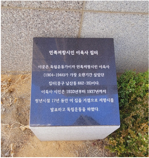
- This study aims to investigate how Literature museums, mediated by a specific writer or literary work, form an attractive placeness and manifest a unique locality. To this end, qualitative spatial analysis and language network analysis were conducted on four domestic literary spaces dedicated to the poet Yi Yuk-sa (Yi Yuk-sa Memorial Hall in Andong, Yi Yuk-sa Memorial Hall and Daegu Prison History Hall in Daegu, and Cultural Space 264 in Seoul). The analysis empirically confirmed that despite sharing the same figure of poet Yi Yuk-sa, completely different dimensions of locality emerged depending on the physical and historical context of each region. Andong expressed its locality by highlighting the poet’s literary roots and authenticity as his birthplace. Daegu manifested a locality centered on the narrative of his resistant practices during his youth and a macroscopic collective memory. Meanwhile, Seoul presented a locality that intertwined his literary peak with the daily lives of local residents. In particular, the process of overcoming the modern crisis of place loss through the active compromise of local communities suggests that establishing a Literature museum goes beyond a passive exhibition; it is a dynamic spatial practice of strategic placeness-making.
- COLLAPSE
본 연구는 특정 문인 또는 문학작품을 매개로 한 문학관이 어떻게 매력적인 장소성(Placeness)을 형성하고 고유한 지역성(Locality)을 발현하는지 규명하고자 하였다. 이를 위해 ‘시인 이육사’를 테마로 조성된 국내 4곳의 문학관(안동시 이육사 문학관, 대구시 이육사 기념관 및 대구형무소역사관, 서울시 문화공간 이육사)을 대상으로 정성적 공간 분석과 언어 네트워크 분석을 수행하였다. 분석 결과, 시인 이육사라는 동일한 인물임에도 각 지역의 물리적·역사적 맥락에 따라 전혀 다른 차원의 지역성이 발현됨을 실증적으로 확인하였다. 안동시는 시인의 탄생지로서 문학적 뿌리와 진정성을, 대구시는 청년기의 저항적 실천 서사와 거시적 집단 기억을, 서울시는 문학적 절정기와 주민의 일상을 결합한 미시적 지역성을 각각 발현하였다. 특히 현대에 이르러 장소 상실의 위기를 지역사회의 능동적인 타협으로 극복해 낸 과정은, 문학관 조성이 수동적 전시를 넘어 전략적인 ‘장소성 만들기(Placeness-making)’라는 역동적인 공간적 실천(Spatial Practice)임을 시사한다.
-
Understanding the Literature Museum in Geographical Context
- A Case study of Yi Yuksa Literature Museums -
-
-
‘Youth Villages’ Development through Small-Scale, Diverse Livelihoods
소규모 다원적 생업으로 청년마을 만들기
-
Han, Ju-Seong
한주성
- ‘Youth Villages’ development is a support program designed to prevent the outflow of young people from rural areas and to revitalize local …
‘청년마을 만들기’는 지방청년인구 유출을 방지하고 외지청년의 유입을 통해 지역에 활력을 불어넣는 한편 도농 청년들에게 지역탐색과 새로운 삶의 기회를 제공함으로써 참여·협력·혁신에 기반한 로컬 …
- ‘Youth Villages’ development is a support program designed to prevent the outflow of young people from rural areas and to revitalize local communities by attracting young people from other regions. It also provides urban and rural youth with opportunities to explore regions and pursue new ways of life, thereby enhancing local vitality and laying the foundation for a locally driven creative community through participation, collaboration, and innovation. This study aims to identify what kinds of livelihoods have been established in the region through activities operated in certified ‘Youth Villages’.
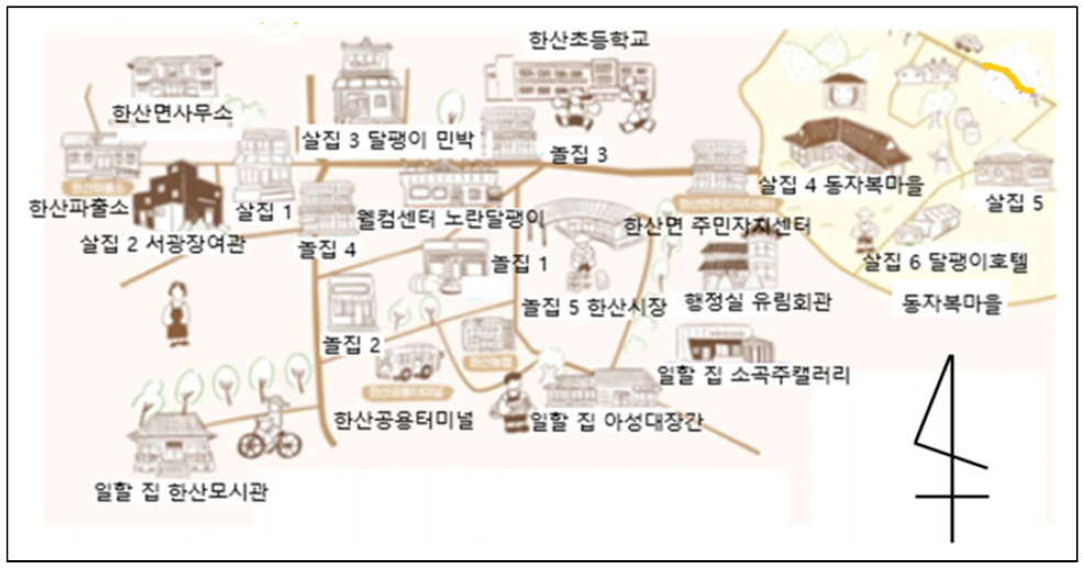
In building ‘Youth Villages’, about three-quarters of the 51 villages are located in rural, mountain, and fishing areas. Programs are implemented to enhance local vitality, including regional living experiences, job experimentation, the creation of residential and community activity spaces, and exchange and communication events. Looking at the main types of activities in the ‘Youth Village’ programs, activities related to mutual growth or entrepreneurship accounted for the largest share, about one-quarter of the total. Among the livelihoods, living-experience programs attracted many residents from major regional cities, and the participants’places of residence were mostly the areas where the ‘Youth Villages’ were located or the participants’ home regions within those areas. Employment and entrepreneurship activities were carried out on a small scale. Although the types of businesses were very diverse, they were mostly operated in villages where cafés or guesthouses were run alongside residents’ main occupations. The ‘Youth Village’ programs can have positive effects by providing new economic opportunities while also promoting the development of the local economy and strengthening social cohesion. However, even for local youth participating in the ‘Youth Village’ programs, their entrepreneurial activities are not carried out in direct collaboration with local residents. Therefore, cooperation with community members in everyday life and economic activities can be considered the key factor.
- COLLAPSE
‘청년마을 만들기’는 지방청년인구 유출을 방지하고 외지청년의 유입을 통해 지역에 활력을 불어넣는 한편 도농 청년들에게 지역탐색과 새로운 삶의 기회를 제공함으로써 참여·협력·혁신에 기반한 로컬 창조커뮤니티의 토대를 조성하는 지원 사업이다. 본 연구는 청년마을을 대상으로 운영되는 활동 및 그 구성, 그리고 지역커뮤니티 내에서 인증마을의 생업이 지니는 특성을 파악하는 것을 목적으로 한다. 청년마을 만들기는 51개 마을 가운데 약 3/4이 농산어촌에 입지하며, 지역 살아보기(체험), 일거리 실험, 주거·커뮤니티의 활동 공간조성, 교류·소통행사 등으로 지역 활력을 높이는 프로그램을 운영한다. 청년마을 운영프로그램의 주요 활동유형을 보면 상생이나 창업이 전체의 약 1/4로 가장 많았다. 그리고 생업 중에서 살아보기 체험은 각 지방 대도시의 주민들이 많았고, 체험자의 거주지역은 청년마을이 입지한 지역과 그 지방 출신자가 대체로 많았다. 취업과 창업은 소규모로 창업의 업종이 매우 다양하나 본업과 더불어 카페나 게스트하우스가 많은 마을에서 운영되었다. 청년마을 만들기는 새로운 경제적 기회를 제공하는 동시에 지역경제발전과 사회적 결속력도 높이는데 긍정적인 효과를 가져 올 수 있다. 다만 청년마을을 구축하는 사업자로서 지역 또는 외지청년은 지역주민과 함께 창업한 것이 아니기 때문에 일상생활을 포함한 경제활동에서 지역주민과의 협력이 가장 중요한 과제라 할 수 있다.
-
‘Youth Villages’ Development through Small-Scale, Diverse Livelihoods
-
-
Changes in Urban Fabric and Landownership in the Old Yongsan Area of Seoul during the Japanese Colonial Period
일제강점기 서울 구용산 지역의 도시조직과 토지소유 변화
-
Jeon, Yeong-jun · Yang, Seung-woo
전영준 · 양승우
- Wonhyo-ro in Yongsan-gu, Seoul, underwent significant morphological changes as it transformed from the Yongsan Riverfront area in the late Joseon period into …
본 연구는 용산강 일대의 도시형태 변화를 지적도와 토지조사부를 바탕으로 일본인 거류지 형성기(1876~1913년), 일본인 거류지 정착기(1913~1929년)로 구분하고, 도로, 필지, 지목, 소유주를 중심으로 분석하였다. …
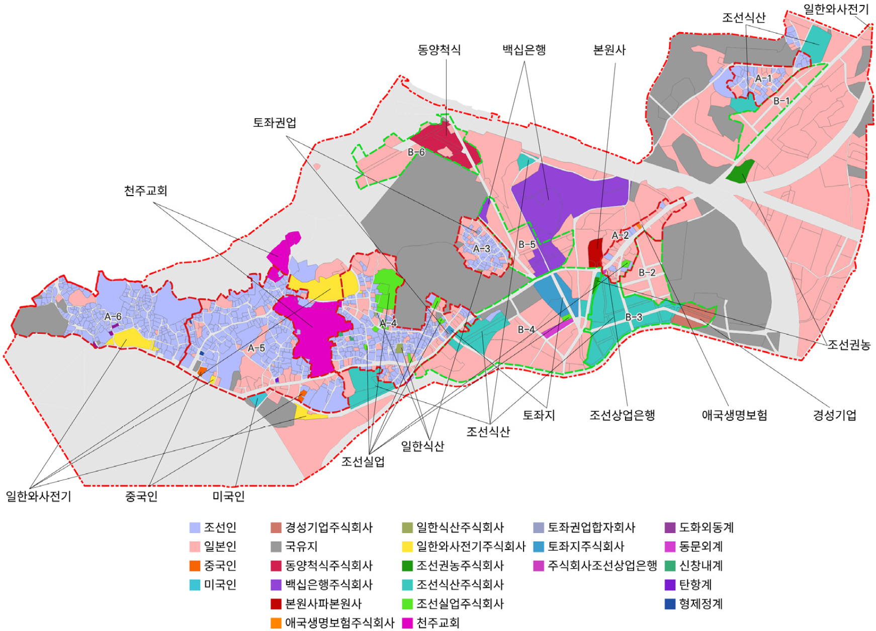
- Wonhyo-ro in Yongsan-gu, Seoul, underwent significant morphological changes as it transformed from the Yongsan Riverfront area in the late Joseon period into Old Yongsan, a Japanese settlement during the Japanese colonial period. This study examines the urban morphological changes of Wonhyo-ro from the late Joseon period to the Japanese colonial period, focusing on roads, land parcels, land categories, and land ownership. Based on cadastral maps and land survey registers, the analysis divides the process into three phases: the late Joseon period, the formation of the Japanese settlement, and its consolidation. The findings show that the urban fabric of the late Joseon period was strongly influenced by topographical conditions, while the colonial period saw the development of new urban areas around railways and road networks, parcel subdivision, and the expansion of Japanese land ownership. In particular, Japanese settlements were formed mainly in newly developed areas rather than in the existing urban fabric, while the late Joseon urban fabric and new developments became spatially connected, accompanied by changes in land use.
- COLLAPSE
본 연구는 용산강 일대의 도시형태 변화를 지적도와 토지조사부를 바탕으로 일본인 거류지 형성기(1876~1913년), 일본인 거류지 정착기(1913~1929년)로 구분하고, 도로, 필지, 지목, 소유주를 중심으로 분석하였다. 서울 용산구 원효로는 조선후기 용산강 일대에서 일제강점기 일본인 거류지인 구용산으로 변화하며 도시형태가 크게 바뀐 지역이다. 분석 결과 조선후기 도시조직은 지형 조건과 기존 취락 구조의 영향을 크게 받았으며, 일제강점기에는 철도·도로망 주변의 신개발지 조성, 필지 분할이 일어났고 일본인 소유가 확대되었다. 특히 일본인 거류지는 기존 도시조직보다 신개발지를 중심으로 형성되었고, 이후 조선후기 도시조직과 신개발지가 연담화되며 토지이용 변화가 나타났다. 이는 일본인 거류지 및 소유 확대, 식민회사 개발이 원효로 일대 공간구조 변화의 핵심 요인으로 작용했음을 보여준다.
-
Changes in Urban Fabric and Landownership in the Old Yongsan Area of Seoul during the Japanese Colonial Period
-
-
A Study on the Spatial Limitations of Agricultural Mechanization and the Sustainability of Traditional Agricultural Technologies
- A Case Study of Goun-ri, Suanbo-myeon, Chungju-si -
농업기계화의 공간적 한계와 전통 농업기술의 지속 가능성 연구 - 충주시 수안보면 고운리를 사례로 -
-
Kim, Jeong Yun · Kim, Hwa Mi · Kwon, Yong-Whuy
김정윤· 김화미 · 권용휘
- This study examines the natural environmental conditions and sustainability of the continued use of ox-plowing after the spread of agricultural mechanization, focusing …
본 연구는 충청북도 충주시 수안보면 고운리를 사례로, 농업기계화 이후에도 우경이 잔존하게 된 자연환경적 조건과 지속 가능성을 검토하였다. 이를 위해 DEM 기반 경사도 …
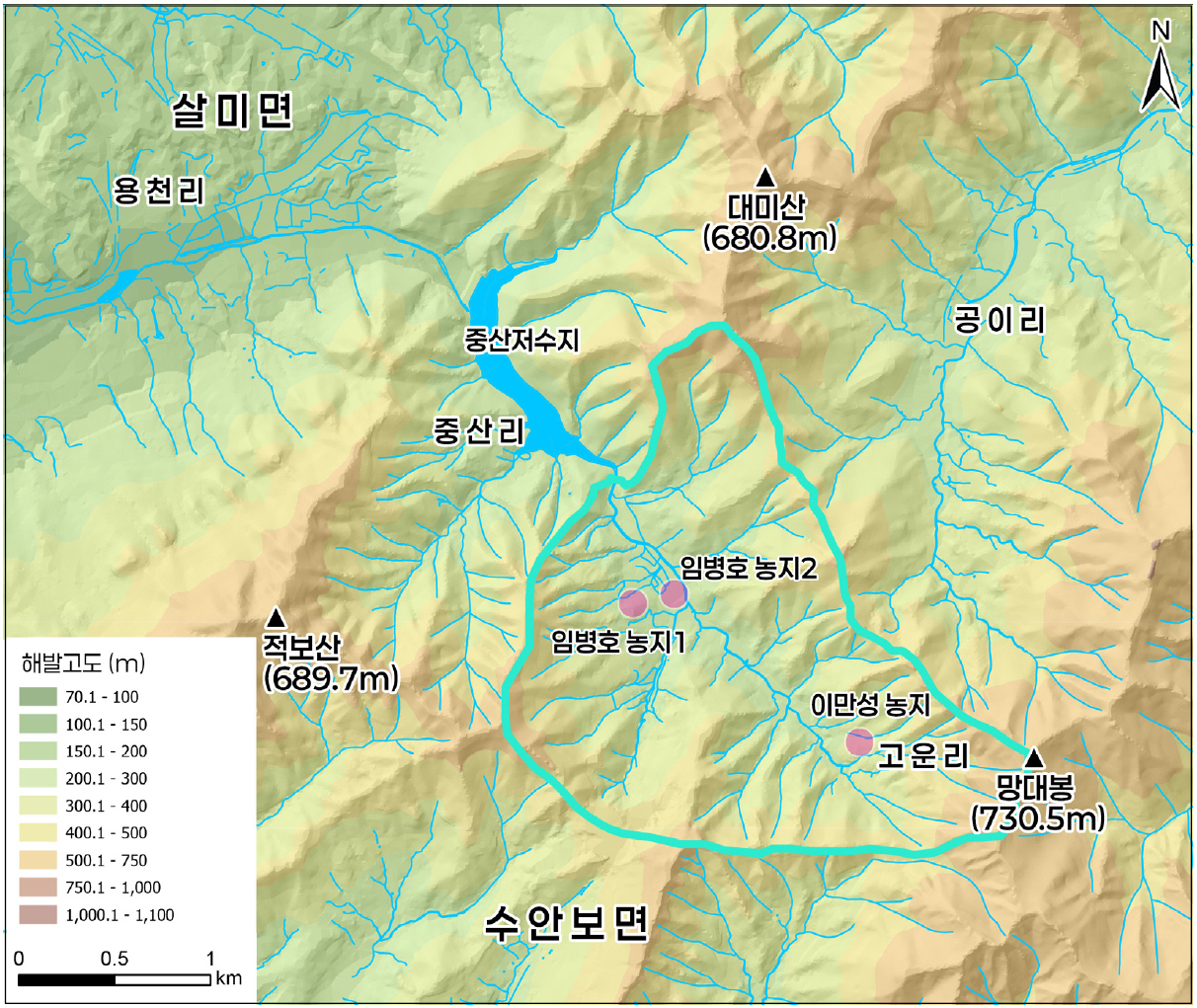
- This study examines the natural environmental conditions and sustainability of the continued use of ox-plowing after the spread of agricultural mechanization, focusing on Gowoon-ri, Suanbo-myeon, Chungju-si, Chungcheongbuk-do. For this purpose, DEM-based slope analysis, an examination of gravel and boulder distribution using soil environmental data and field surveys, and in-depth interviews with ox-plowing farmers and local residents were conducted. The results show that Gowoon-ri is a mountainous valley-floor settlement located in the uppermost reach of Jungsancheon Stream, where settlements and farmland are distributed mainly along narrow valley floors and piedmont slopes. Farmland locally referred to by residents as “biyalbat” is generally located on relatively steep slopes, and gravel and boulders are widely distributed across the cultivated fields. Residents recognized slope and gravel as major constraints on the operation of agricultural machinery, and ox-plowing was found to be a selectively maintained agricultural technique under these conditions. In particular, trained draft cattle can work on sloping and gravel-rich fields, making ox-plowing useful in areas where agricultural mechanization cannot be sufficiently applied. In this respect, ox-plowing in Gowoon-ri should be understood not simply as the survival of a traditional farming technique, but as a local agricultural technique that has been maintained by compensating for the limitations of agricultural mechanization under the natural environmental constraints of mountainous farmland. Meanwhile, the sustainability of ox-plowing emerged as a separate issue from natural environmental conditions. Gowoon-ri is a mountain village characterized by continuous population decline, aging, and the absence of successor generations. The decline in people with experience handling draft cattle and the interruption of technical transmission were also confirmed. Therefore, although ox-plowing is currently maintained due to natural environmental necessity, its future transmission is considered highly limited. This study is significant in that it interprets ox-plowing not merely as a form of folk transmission or a remnant of past agricultural technology, but as a practical agricultural technique selectively maintained in spaces where agricultural mechanization reaches its limits.
- COLLAPSE
본 연구는 충청북도 충주시 수안보면 고운리를 사례로, 농업기계화 이후에도 우경이 잔존하게 된 자연환경적 조건과 지속 가능성을 검토하였다. 이를 위해 DEM 기반 경사도 분석, 토양환경자료와 현장조사를 통한 자갈 및 거력 분포 분석, 우경 농가와 지역 주민을 대상으로 한 심층면담을 실시하였다. 분석 결과, 고운리는 중산천 최상류부에 위치한 산지성 곡저 지형으로, 취락과 농경지는 좁은 곡저부와 산록 사면을 중심으로 분포하였다. 주민들이 ‘비얄밭’이라 부르는 경작지는 주로 경사가 큰 사면에 위치하였으며, 경작지에는 자갈과 거력이 광범위하게 분포하고 있었다. 주민들은 경사와 자갈을 농기계 운용의 주요 제약 요인으로 인식하였으며, 우경은 이러한 환경에서 선택적으로 유지되는 농업기술로 나타났다. 특히 숙련된 일소는 경사와 자갈이 많은 경작지에서도 작업이 가능하여, 농업기계화가 충분히 적용되기 어려운 공간에서 활용되고 있었다. 이러한 점에서 고운리의 우경은 단순한 전통 농업기술의 잔존이 아니라, 산지 농경지의 자연환경적 제약 속에서 농업기계화의 한계를 보완하며 유지되어 온 지역적 농업기술로 해석된다. 한편 우경의 지속 가능성은 자연환경 조건과는 별개의 문제로 나타났다. 고운리는 지속적인 인구 감소와 고령화, 후속세대 부재가 두드러지는 산촌 취락이며, 일소를 다룰 수 있는 경험자의 감소와 기술 전승의 단절도 확인되었다. 따라서 현재 우경은 자연환경적 필요성에 의해 유지되고 있으나, 향후 전승 가능성은 매우 제한적인 것으로 판단된다. 본 연구는 우경을 민속 전승이나 과거 농업기술의 잔존으로만 보지 않고, 농업기계화의 한계공간에서 선택적으로 유지된 실천적 농업기술로 해석하였다는 점에서 의의를 가진다.
-
A Study on the Spatial Limitations of Agricultural Mechanization and the Sustainability of Traditional Agricultural Technologies
- A Case Study of Goun-ri, Suanbo-myeon, Chungju-si -
-
-
Sediment Source Tracing Using Fallout Radionuclides and Connectivity Assessment in the Saguling Dam Reservoir Catchment, Indonesia
방사성동위원소를 이용한 사굴링댐 저수지 퇴적물의 기원지 추정 및 토사 연결성의 정량적 분석
-
Lim, Young Shin · Ki, Shinwoo · Kim, Yeawon · Luki Subehi · Kim, Jin Kwan
임영신 · 기신우 · 김예원 · Luki Subehi · 김진관
- This study monitored reservoir sediment accumulation at two locations in the Saguling Dam reservoir, Indonesia, from December 2021 to July 2022—a period …
본 연구는 인도네시아 사굴링 댐 저수지 유역을 대상으로 라니냐에 따른 wet dry season이 나타났던 2021년 12월부터 2022년 7월까지 저수지 두 지점에서 퇴적물을 …
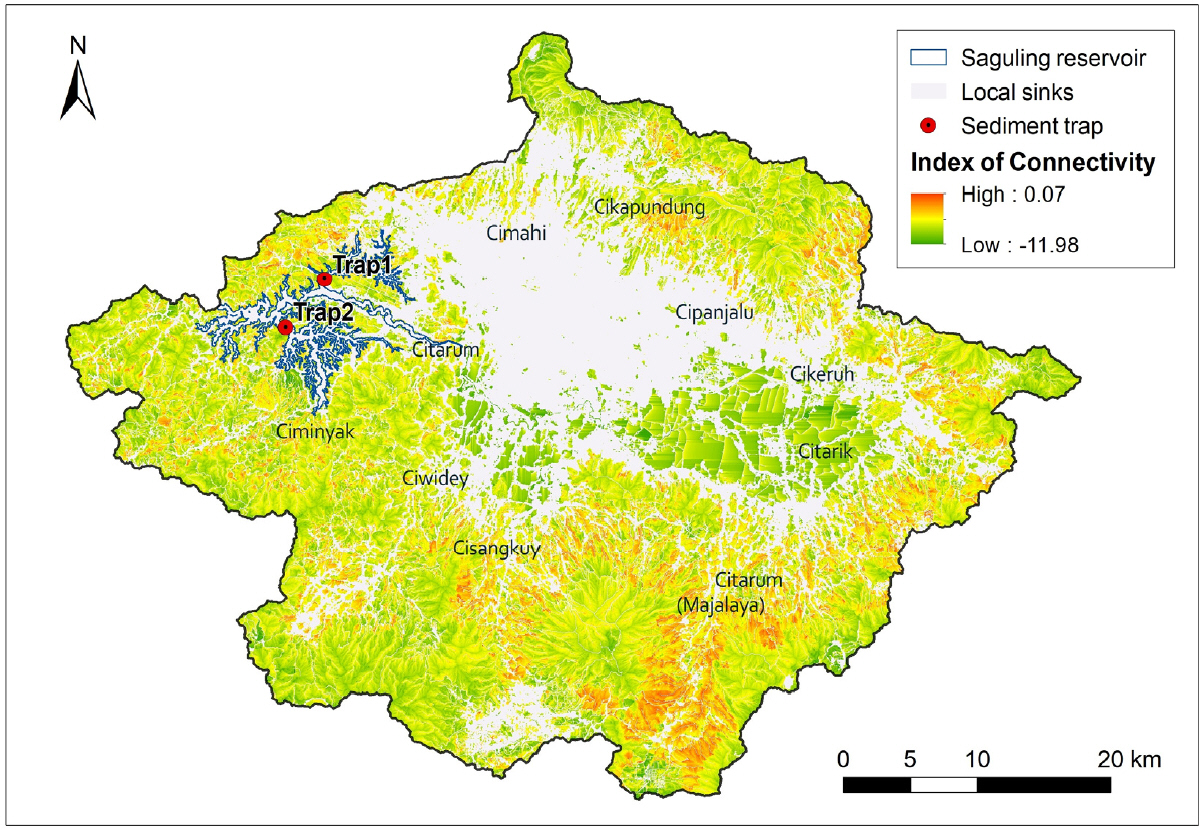
- This study monitored reservoir sediment accumulation at two locations in the Saguling Dam reservoir, Indonesia, from December 2021 to July 2022—a period characterized by La Niña–induced wet-dry conditions—and traced sediment sources using fallout radionuclides excess 210Pb(210Pbex). At the site near the tributary inflow, immediate sedimentation patterns were observed, reaching a peak deposition rate(6.856 kg/m2) during concentrated rainfall events. Conversely, the internal reservoir site exhibited low sedimentation rates throughout the monitoring period; fine suspended materials passed through the stagnant water body, resulting in continuous influx and deposition. Based on the statistically significant differences in 210Pbex activities between forest topsoil and riverbank materials, sediment source fingerprinting revealed a higher contribution from riverbanks during the wet season. These results suggest that while overall low catchment connectivity limited the transport of slope topsoil to the stream, runoff concentrated along highly connected slopes triggered riverbank erosion and failure, delivering substantial amounts of bank material directly into the channel network system. Under prolonged wet season conditions, rapid sedimentation at the reservoir inlet occurs simultaneously with the continuous accumulation of fine-grained sediment within stagnant reservoir zones, accelerating the loss of storage capacity in the Saguling Dam. Therefore, to fundamentally mitigate reservoir siltation, tailored sediment management strategies must prioritize highly connected slopes and erosion-prone riverbank reaches alongside general topsoil conservation. The findings of this study provide foundational data for controlling sediment influx and establishing efficient, sustainable reservoir management strategies.
- COLLAPSE
본 연구는 인도네시아 사굴링 댐 저수지 유역을 대상으로 라니냐에 따른 wet dry season이 나타났던 2021년 12월부터 2022년 7월까지 저수지 두 지점에서 퇴적물을 모니터링하고, 방사성동위원소를 추적자로 이용하여 퇴적물의 기원지를 추정하였다. 지류 유입부 인근 지점은 집중강우가 발생한 시기에 최대 퇴적률(6.856kg/m2)을 기록하며 즉각적인 퇴적 양상이 관측되었다. 반면, 저수지 내부 지점은 모니터링 전기간 동안 낮은 퇴적률이 나타났으며, 세립질 부유물질이 뜬짐 형태로 긴 정체 수역을 통과하여 샘플링 지점에 지속적으로 유입 및 퇴적되었다. 산사면 표토와 하안 물질의 210Pbex 값이 통계적으로 유의미한 차이를 보여 이를 추적자로 이용한 기원지 분석을 수행한 결과, 우기 동안 하안 물질이 상대적으로 더 높은 기여율을 나타냈다. 이러한 결과는 유역 전반의 낮은 연결성으로 인해 사면 표토의 하천 도달률은 낮은 반면, 고연결성 사면으로 집중된 유출수가 하안 침식 및 붕괴를 유발하여 다량의 하안 물질을 하천에 직접 공급했음을 시사한다. 특히 우기가 장기화되는 조건에서는 저수지 유입부의 급격한 퇴적과 저수지 내부 정체 수역 내 세립질 토사의 지속적 누적이 동시에 진행되어 사굴링 댐의 저수용량을 빠르게 감소시킬 수 있다. 따라서 사굴링 댐 저수지의 퇴사 문제를 근본적으로 해결하기 위해서는 유역 전반의 표토 침식 제어뿐만 아니라, 고연결성 사면 및 하안 침식 취약 구간을 최우선 관리 구역으로 선정하여 맞춤형 토사 관리 대책을 적용할 필요가 있다. 본 연구 결과는 저수지 내 유입 토사를 제어하고 효율적인 저수지 관리 전략을 수립하는데 기초자료로 활용될 수 있다.
-
Sediment Source Tracing Using Fallout Radionuclides and Connectivity Assessment in the Saguling Dam Reservoir Catchment, Indonesia
-
-
Spatio-temporal Changes and Future Projections of Summer Heat Waves in South Korea in the 21st Century
21세기 우리나라 여름철 열파(폭염) 발생의 시공간적 변화와 미래 전망
-
Choi, Gwangyong
최광용
- The purpose of this study is to examine the spatio-temporal changes of heat waves in the early 21st century and their …
본 연구는 우리나라의 21세기 초반의 열파(폭염) 시공간적 변화 특징과 21세기 후반의 그 변화 전망을 밝히는 것을 목적으로 한다. 이를 위해, 21세기 초반의 …
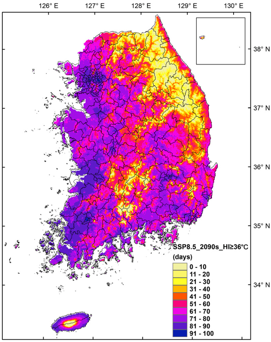
- The purpose of this study is to examine the spatio-temporal changes of heat waves in the early 21st century and their projected changes in the later 21st century in South Korea. To do this, heat index (HI), which quantifies human-sensible temperature considering the synergistic effects of high temperature and high humidity, is calculated at daily scale for the early 21st century using the MKPRISM v.2.1 reanalysis data set and for the later 21st century using high-resolution climate change scenario data for South Korea based on the latest greenhouse gas emission scenarios (Shared Socioeconomic Pathways, SSP). Temporal comparisons show that under both high (SSP5-8.5) and mid-level (SSP2-4.5) greenhouse gas emission scenarios, the mega-heat waves exceeding emergency level (exceeding 42°C of daily mean HI) will occur more frequently with more intensity toward the broader regions near large rivers in Korea in the later 21st century (2091~2100) compared to those for the present. In terms of duration, while mega-heat waves in the early 21st century are limited to the peak summer period (late July to early August) of specific years only, based on SSP5-8.5 (SSP2-4.5) the extreme episode persisting for 60 (30) consecutive days or longer around the peak summer period is projected to frequently occur around the middle and lower reaches of major rivers in the later 21st century. These findings indicate that the government must take proactive measures to prepare for massive casualties caused by mega-heat waves particularly in densely populated metropolitan areas as well as for the drastic reduction in water resources and food production resulting from mega-droughts in rural areas along major rivers, which are identified as key hot spots of mega-heat waves in South Korea in the later 21st century.
- COLLAPSE
본 연구는 우리나라의 21세기 초반의 열파(폭염) 시공간적 변화 특징과 21세기 후반의 그 변화 전망을 밝히는 것을 목적으로 한다. 이를 위해, 21세기 초반의 경우 MKPRISM v.2.1 재분석 자료를, 21세기 후반의 경우 최신 온실가스 배출 시나리오(공통사회경제경로, SSP)에 기반한 ‘남한상세 고해상도 기후변화 시나리오 자료’를 활용하여 일 단위로 고온과 다습의 복합적 영향을 고려한 체감 온도 지수인 ‘열지수(heat index)’ 자료를 구축하였다. 21세기 초반과 비교하여 온실기체 고배출(SSP5-8.5)와 중배출(SSP2-4.5) 시나리오 모두 현재 시점의 비상 수준(일평균 열지수 42°C 이상)을 초과하는 강력한 ‘메가 열파 또는 폭염(mega-heat wave)’이 21세기 후반(2091~2100년)에 우리나라 대하천 주변 지역을 중심으로 현재보다 더 넓은 범위에서, 훨씬 더 빈번하게, 그리고 훨씬 더 강하게 발생할 것으로 전망되었다. 또한 발생기간 측면에서 메가 열파(폭염)는 21세기 초반에는 특정해의 성하기(7월 하순~8월 초순)에만 국한되어 나타나지만, 21세기 후반에는 SSP5-8.5(SSP2-4.5) 기준 대하천 중하류 주변 지역에서 성하기를 전후로 60일(30일) 이상 동안 연속적으로 지속되는 극한현상이 빈번하게 발생할 것으로 전망된다. 이러한 연구 결과들은 21세기 후반 미래 메가 열파(폭염) 핵심 발생 지역인 대하천 주변의 인구가 집중된 대도시 대규모 인명 피해와 대하천 주변 농촌 지역의 메가 가뭄으로 인한 수자원 부족 및 식량 생산 급감 피해에 대비한 선제적 대응책이 국가적 수준에서 마련되어야 함을 가리키고 있다.
-
Spatio-temporal Changes and Future Projections of Summer Heat Waves in South Korea in the 21st Century
-
-
Economic Geography in the Age of AI: Disciplinary Relevance and the Rationale for Economic Geography Education
AI 시대, 경제지리학의 유용성과 경제지리 교육의 존재 이유
-
Lee, Jong-Ho · Cho, Chul-Ki
이종호 · 조철기
- This study reexamines the disciplinary relevance of economic geography in the age of AI and, on that basis, proposes a direction for …
본 연구는 AI 시대 경제지리학의 학문적 유용성을 재검토하고, 이를 토대로 경제지리 교육이 나아가야 할 방향을 제안한다. 생성형 AI는 공간 데이터 분석, 입지 …
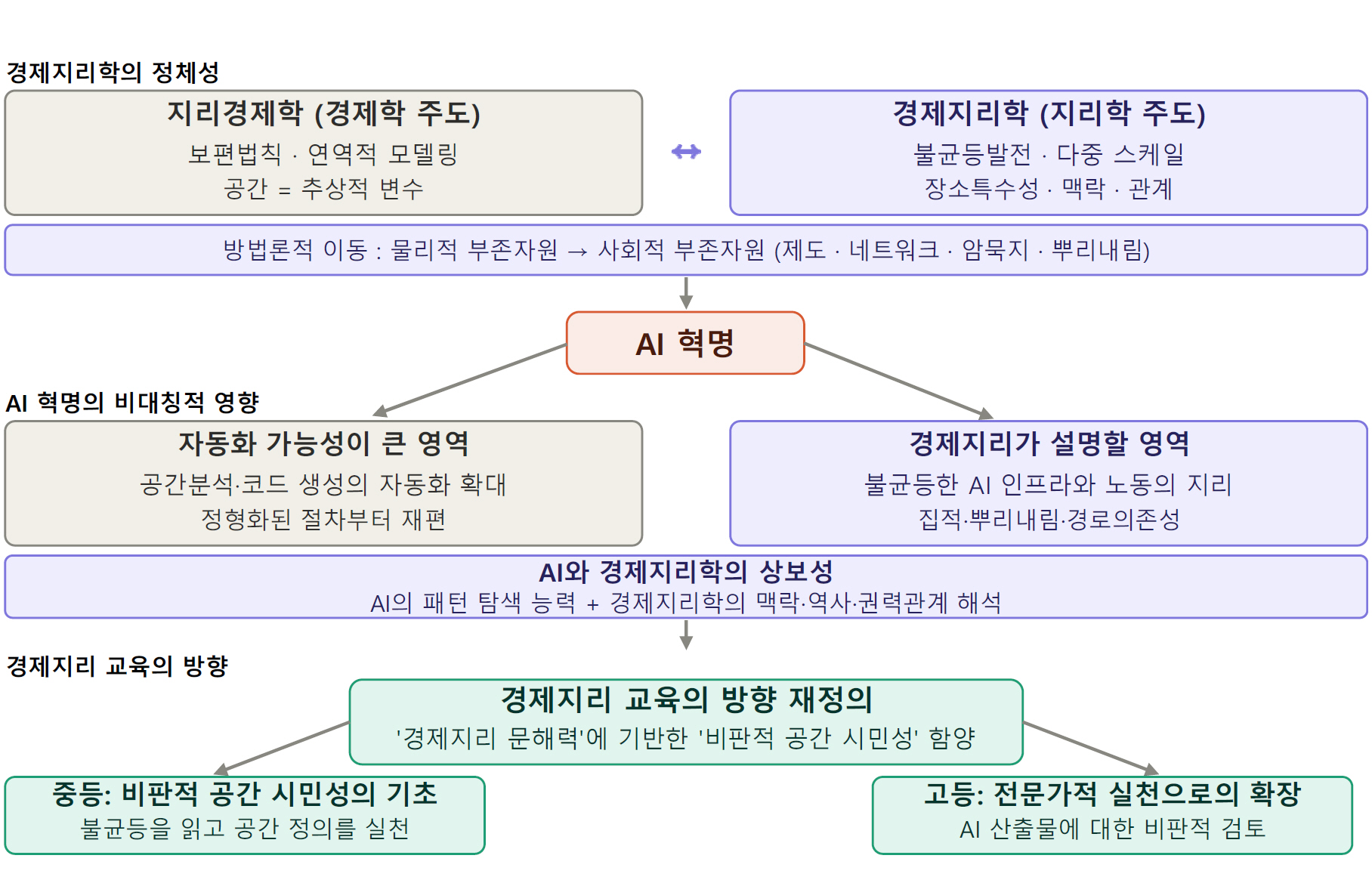
- This study reexamines the disciplinary relevance of economic geography in the age of AI and, on that basis, proposes a direction for economic geography education. Generative AI is expanding the automation and assistance of structured quantitative tasks in economic geography, including spatial data analysis, location optimization, and regional forecasting; approaches in geographical economics centered on deductive modeling are relatively more exposed to this pressure. At the same time, AI is itself a new phenomenon that economic geography must explain. The spatial concentration of data centers, semiconductor clusters, and AI talent demonstrates that the technology is deeply rooted in particular places, accelerating uneven development. The conceptual resources of economic geography—agglomeration economies, embeddedness, and path dependence—remain effective analytical tools for accounting for these new geographies of inequality. This study conceptualizes the ability to interpret and contextualize phenomena unfolding in economic space through economic-geographical concepts—a capacity distinct from GIS- or geomedia-centered spatial literacy—as “economic-geographical literacy,” and the capacity to pursue and enact spatial justice, grounded in insight into an unequal world, as “critical spatial citizenship,” positioning the former as the epistemological foundation of the latter. Ultimately, the relevance of economic geography in the age of AI lies in its capacity to interpret spatial inequality in context, and cultivating this interpretive capacity as literacy and fostering it into critical spatial citizenship constitute the rationale for economic geography education.
- COLLAPSE
본 연구는 AI 시대 경제지리학의 학문적 유용성을 재검토하고, 이를 토대로 경제지리 교육이 나아가야 할 방향을 제안한다. 생성형 AI는 공간 데이터 분석, 입지 최적화, 지역 예측 등 경제지리학의 계량적 영역을 빠르게 자동화하고 있으며, 보편 법칙을 지향하는 지리경제학적 접근일수록 이 압력에 더 취약하다. 동시에 AI는 경제지리학이 설명해야 할 새로운 현상이기도 하다. 데이터센터, 반도체 클러스터, AI 인재의 공간적 집중은 기술이 특정 장소에 깊이 뿌리내려 있음을 보여주며 불균등발전을 가속하고 있다. 집적경제, 뿌리내림, 경로의존성 등 경제지리학의 개념적 자원은 이러한 새로운 불균등을 해명하는 유효한 분석 도구다. 본 연구는 경제공간에서 전개되는 현상을 경제지리 개념으로 해석·맥락화하는 능력을 ‘경제지리 문해력’으로, 불균등한 세계에 대한 통찰을 토대로 공간 정의를 지향·실천하는 역량을 ‘비판적 공간 시민성’으로 정의하고, 전자를 후자의 인식론적 토대로 규정한다. AI 시대 경제지리학의 유용성은 공간 불균등을 맥락적으로 해석하는 능력에 있으며, 그 해석 능력을 문해력으로 함양하고 비판적 공간 시민성으로 배양하는 것이 경제지리 교육의 존재 이유이다.
-
Economic Geography in the Age of AI: Disciplinary Relevance and the Rationale for Economic Geography Education
-
-
Evaluation and Improvement of National Territory Education in Korea
- The Case of the Youth Territory Education Support Program -
한국의 국토교육에 대한 평가와 개선 방향 - 청소년 국토교육 지원사업을 사례로 -
-
Kim, Minji · Jeon, Bong Kyung
김민지 · 전봉경
- This study aims to evaluate the Youth National Territory Education Support Program, implemented since 2011, and to derive improvement strategies in response …
본 연구는 2011년부터 추진된 「청소년 국토교육 지원사업」을 대상으로, 변화한 시대적 상황에 대응한 평가와 개선방안 도출을 목적으로 한다. 이를 위해 초·중등학교 교사 127명에 …
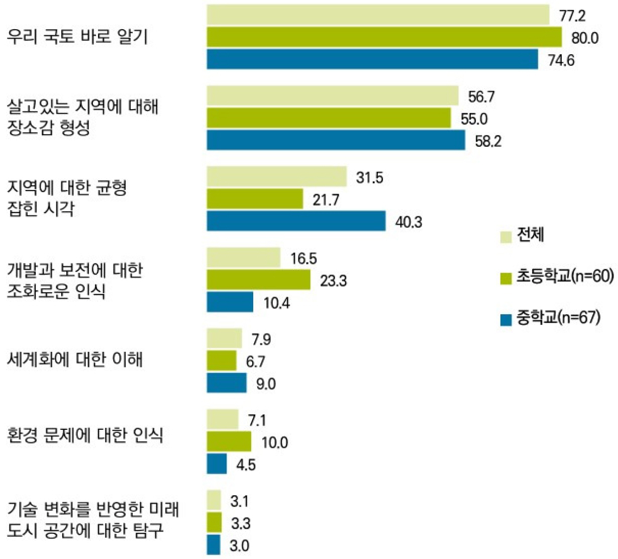
- This study aims to evaluate the Youth National Territory Education Support Program, implemented since 2011, and to derive improvement strategies in response to changing social conditions. To achieve these goals, a survey of 127 elementary and middle school teachers and in-depth interviews with 18 stakeholders were conducted, alongside a comparative analysis with the Economic Education and Unification Education programs. The analysis identifies three structural problems in the program: an absence of clear objectives and direction, ambiguity in both the target audience and the very concept of national territory education, and insufficient content quality and promotion. In particular, the conceptual confusion is interpreted as the field-level manifestation of “national territory” as a discursive product—a multivalent and inclusive concept that has been continuously reconstructed across eras and actors. Accordingly, this study proposes the following improvement directions: dual objectives comprising community-based education for upper-elementary students and future territorial-space education for middle school students; user-centered digital content such as high-quality core materials accompanied by teacher guides and a VR-based “Gukto Dibeot” (tentative name); the training of teachers and experts together with the incorporation of social issues such as local extinction and balanced regional development; and expansion toward lifelong territorial education supported by an independent legal basis. This study is significant in that it offers the first empirical diagnosis of a program that had gone without comprehensive evaluation for over a decade, and demonstrates how the discursive reconstruction of the concept of national territory materializes within the educational field.
- COLLAPSE
본 연구는 2011년부터 추진된 「청소년 국토교육 지원사업」을 대상으로, 변화한 시대적 상황에 대응한 평가와 개선방안 도출을 목적으로 한다. 이를 위해 초·중등학교 교사 127명에 대한 설문조사와 이해관계자 18명에 대한 심층면접을 실시하고, 「경제교육」 및 「통일교육」과 비교분석하였다. 분석 결과, 목적·방향성의 부재, 교육 대상과 국토교육 개념의 모호성, 콘텐츠 품질 미흡과 홍보 부족이라는 세 가지 구조적 문제를 확인했다. 특히 개념의 혼선은 국토가 시대와 주체에 따라 재구성되어 온 담론적 산물이자 다의적·포용적 개념임이 교육 현장에서 재현된 결과로 해석된다. 이에 본 연구는 초등 고학년 지역·공동체 중심 교육과 중학생 미래 국토공간 교육이라는 이원화된 목적, 지도서를 겸비한 고품질 핵심 콘텐츠와 VR 기반 ‘국토 디벗’(가칭) 등 수요자 중심 디지털 콘텐츠, 교사·전문가 양성과 사회적 이슈 반영, 생애주기별 교육으로의 확장과 독자적 법적 근거 마련을 개선 방향으로 제안하였다. 본 연구는 그동안 미평가 상태였던 사업을 최초로 실증 진단하고, 국토 개념의 담론적 재구성이 교육 현장에서 구현되는 양상을 제시했다는 점에서 의의가 있다.
-
Evaluation and Improvement of National Territory Education in Korea
- The Case of the Youth Territory Education Support Program -
-

-
Beyond Q Methodology towards Q Pedagogy
- Bringing Students’ Subjectivity into the Design and Practice of Geography Instruction -
Q 방법론을 너머 Q페다고지로 - 학생들의 주관성을 지리 교수·학습 설계와 실천에 도입하기 -
-
Lee, Yunmi · Cho, Chul-Ki
이윤미 · 조철기
- This study reconceptualizes Q methodology as a pedagogical tool in geography education and proposes Q pedagogy, exploring its potential and challenges. As …
본 연구는 Q 방법론을 지리교육의 교수학적 도구로 재개념화하여 Q 페다고지(Q pedagogy)를 제안하고, 그 가능성과 과제를 탐색하였다. Q 방법론은 양적·질적 접근을 결합하여 학생의 …
- This study reconceptualizes Q methodology as a pedagogical tool in geography education and proposes Q pedagogy, exploring its potential and challenges. As a mixed methodology combining quantitative and qualitative approaches, Q methodology enables the systematic exploration of students’ subjectivity, values, and beliefs. Applied to classroom practice, Q pedagogy encourages learners to express, share, and discuss their perspectives, thereby fostering critical thinking and mutual understanding. The study outlines the instructional procedures of Q pedagogy—lesson design, Q sorting, factor analysis, discussion, and synthesis—and examines barriers teachers may face, highlighting the importance of professional development. Ultimately, Q pedagogy has significant potential as an instructional strategy that advances student-centered, participatory geography education and supports the cultivation of democratic and critical citizenship.
- COLLAPSE
본 연구는 Q 방법론을 지리교육의 교수학적 도구로 재개념화하여 Q 페다고지(Q pedagogy)를 제안하고, 그 가능성과 과제를 탐색하였다. Q 방법론은 양적·질적 접근을 결합하여 학생의 주관성과 가치, 신념을 탐구할 수 있는 대표적 혼합 방법론으로, 이를 수업에 적용하면 학습자가 자신의 생각을 표현·공유하고 토론을 통해 비판적 사고와 상호이해를 기를 수 있다. 연구에서는 Q 페다고지의 절차(수업 설계–Q 분류–요인 분석–토론–정리)를 제시하고, 실제 적용 과정에서 교사가 직면하는 장벽과 이를 극복하기 위한 전문성 개발의 필요성을 논의하였다. Q 페다고지는 단순한 토론 수업을 넘어 학습자 중심의 참여적 지리수업을 구현하고, 민주적 시민 역량을 함양할 수 있는 유의미한 교수 전략으로서 발전 가능성이 크다.
-
Beyond Q Methodology towards Q Pedagogy
- Bringing Students’ Subjectivity into the Design and Practice of Geography Instruction -
-
-
The Effects of Regional Congruency of Background Music in Geography Learning Videos on Middle School Students’ Memory, Interest, and Perceived Vividness
지리 학습 영상에서 배경음악의 지역 조화도가 중학생의 기억, 흥미 및 지각된 생생함에 미치는 영향
-
Park, Euihyun
박의현
- The purpose of this study was to examine the effects of the regional congruency of background music in geography learning videos on …
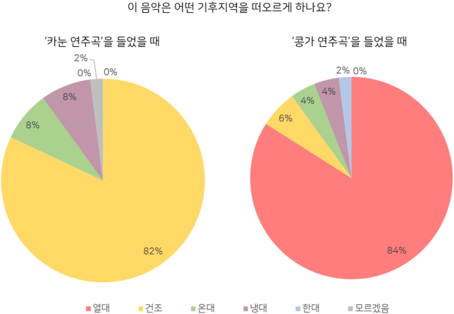
본 연구의 목적은 지리 학습 영상에서 배경음악의 지역 조화도가 중학생의 기억, 흥미, 지각된 생생함에 미치는 영향을 검증하는 것이다. 지역 조화도는 언어 정보 …
- The purpose of this study was to examine the effects of the regional congruency of background music in geography learning videos on middle school students’ memory, interest, and perceived vividness. Regional congruency was classified into regional congruency based on linguistic information (Experiment 1) and regional congruency based on musical features (Experiment 2). In Experiment 1, the group exposed to background music with high regional congruency based on linguistic information showed significantly higher levels of interest than the no-music group. For perceived vividness, both the high- and low-congruency groups showed significantly higher levels than the no-music group, whereas no significant difference was found in memory. In Experiment 2, the group exposed to background music with high regional congruency based on musical features showed some positive trends in memory and interest, although the differences were not statistically significant. These findings indicate that the relationship between background music and the region being studied should be considered when selecting background music for geography learning videos and suggest that region-related music can be used as an instructional resource for designing effective geography learning videos.
- COLLAPSE
본 연구의 목적은 지리 학습 영상에서 배경음악의 지역 조화도가 중학생의 기억, 흥미, 지각된 생생함에 미치는 영향을 검증하는 것이다. 지역 조화도는 언어 정보 기반 지역 조화도(실험 1)와 음악적 특성 기반 지역 조화도(실험 2)로 구분하였다. 실험 1에서는 언어 정보 기반 지역 조화도가 높은 배경음악을 제시한 집단이 무음악 집단보다 흥미에서 유의하게 높은 수준을 보였으며, 지각된 생생함에서는 고조화 집단과 저조화 집단 모두 무음악 집단보다 유의하게 높은 수준을 보였다. 반면 기억에서는 유의한 차이가 나타나지 않았다. 실험 2에서는 음악적 특성 기반 지역 조화도가 높은 배경음악을 제시한 집단이 기억과 흥미에서 일부 긍정적인 경향을 보였으나, 통계적으로 유의한 차이는 확인되지 않았다. 이러한 결과는 지리 학습 영상의 배경음악을 선정할 때 학습 지역과의 연관성을 고려할 필요가 있음을 보여주며, 지역 관련 음악을 학습 영상 설계를 위한 교수·학습 자원으로 활용할 수 있음을 시사한다.
-
The Effects of Regional Congruency of Background Music in Geography Learning Videos on Middle School Students’ Memory, Interest, and Perceived Vividness

 REGION AND GEOGRAPHY
 The Korean Association of Regional Geographers
한국지역지리학회
경상남도 진주시 진주대로 501 경상국립대학교 사범대학 지리교육과
Tel: 055-772-2180 / Fax: 055-772-2189 / E-mail: admin@krg.or.kr Copyright© The Korean Association of Regional Geographers. Powered by APUB
Tel: 055-772-2180 / Fax: 055-772-2189 / E-mail: admin@krg.or.kr Copyright© The Korean Association of Regional Geographers. Powered by APUB