
-
-
Transition Dynamics of the Gap Between Overall and Youth Employment Rates Across Regions
- A Markov Transition and Sequential Binary Logit Approach -
지역 전체-청년층 간 고용률 격차의 전이 구조와 변화 경로 - 마르코프 전이와 단계적 이항 로짓 접근 -
-
Park, Sohyun
박소현
- This study investigates the structural patterns and dynamic trajectories of the gap between overall and youth employment rates across regions, and explores …
본 연구는 지역 전체-청년층 간 고용격차의 구조와 변화 경로를 분석하고, 고용격차의 심화 및 고착과 연관된 지역적 특성을 탐색한다. 이를 위해 고용률 격차의 …
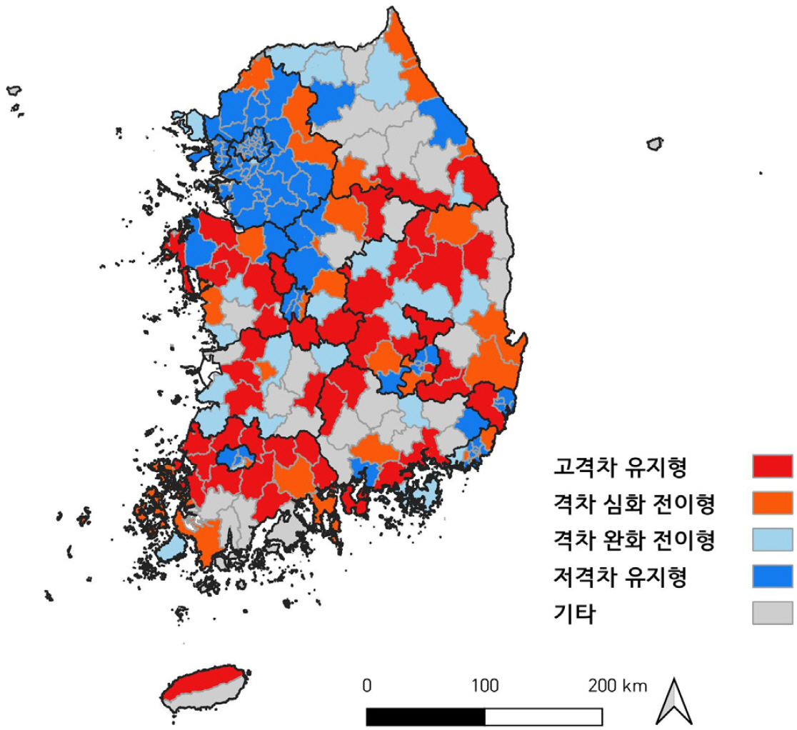
- This study investigates the structural patterns and dynamic trajectories of the gap between overall and youth employment rates across regions, and explores the regional characteristics associated with the persistence of this gap. To this end, regions are classified using relative indicators of the employment rate gap, and a Markov transition model is employed to identify transition probabilities and trajectory patterns. A sequential binary logit model is further applied to examine factors associated with the likelihood of being in specific destination states. The findings show that regions with larger and more volatile gaps tend to remain in or transition toward high-gap states, particularly in non-capital regions. In contrast, higher levels of outbound commuting are associated with trajectories of gap reduction. In addition, regions with a high share of highly educated populations but limited high-skilled employment tend to remain in high-gap states, indicating a structural mismatch between human capital and local labor market conditions. The results underscore the importance of understanding youth employment issues in relation to regional labor market structures and spatial linkages.
- COLLAPSE
본 연구는 지역 전체-청년층 간 고용격차의 구조와 변화 경로를 분석하고, 고용격차의 심화 및 고착과 연관된 지역적 특성을 탐색한다. 이를 위해 고용률 격차의 상대 지표를 활용하여 지역을 군집화하고, 마르코프 전이 모형을 적용하여 군집 유형 간 전이확률을 기반으로 전이 경로를 추정하였다. 또한 단계적 이항 로짓 모형을 통해 특정 도착 군집에 속할 가능성과 연관된 지역적 요인을 분석하였다. 분석 결과, 전체-청년층 간 고용률 격차가 크고 변동성이 높은 지역은 고격차 상태에 머무르거나 심화하는 경향이 강하게 나타났으며, 이러한 전이 패턴은 비수도권에서 상대적으로 뚜렷하게 관측되었다. 반면 외부 노동시장으로의 통근 비중이 높은 지역은 고용률 격차가 완화되는 방향과 연관되는 경향을 보였다. 또한 고학력 인구 비중이 높지만 이를 흡수할 수 있는 고숙련 일자리 기반이 충분하지 않은 지역일수록 고격차 상태에 머무를 가능성이 상대적으로 높게 나타났다. 본 연구의 분석 결과는 청년층 고용 문제를 단일 지표가 아닌 지역 전체 고용 대비 청년층의 상대적 위치 변화라는 관점에서 이해할 필요가 있음을 시사하며, 지역 노동시장의 구조와 공간 위계, 그리고 통근을 포함한 기능적 노동시장 간 연계가 고용격차의 변화 양상과 밀접하게 연관되어 있음을 보여준다.
-
Transition Dynamics of the Gap Between Overall and Youth Employment Rates Across Regions
- A Markov Transition and Sequential Binary Logit Approach -
-
-
Examining the Effect of Residential Environment on Regional Birth Rates
- Focusing on Deteriorated Housing Areas -
정주환경이 지역의 출생률에 미치는 영향 분석 - 노후주거지를 중심으로 -
-
Lee, Hweejung
이휘정
- Low fertility has emerged as a critical urban challenge in South Korea over the past decade, threatening not only the short-term vitality …
지난 십여 년간 한국의 출생률은 급격히 감소해 왔으며, 이는 도시의 단기적 활력뿐 아니라 장기적 지속가능성을 위협하는 주요 도시 문제로 부상하였다. 기존 연구는 …
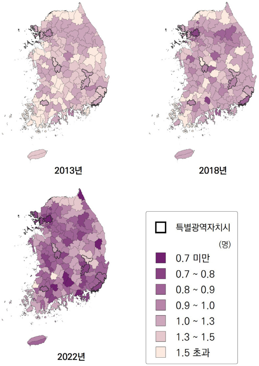
- Low fertility has emerged as a critical urban challenge in South Korea over the past decade, threatening not only the short-term vitality but also the long-term sustainability of cities. While existing studies have predominantly examined the relationship between deteriorated housing environments and population outflow, comparatively little attention has been paid to how ageing housing environments are associated with birth rates. To address this gap, this study constructs a panel dataset covering 229 administrative districts from 2013 to 2022 and employs a Spatial Durbin Model (SDM) to analyze both direct and spatial spillover effects of ageing housing on crude birth rates across local and neighboring jurisdictions. The findings reveal that ageing housing is negatively associated with birth rates in both the districts in question and their surrounding areas, with the spillover effects on adjacent regions found to be 2.8 times greater than the direct effects on the focal district. These results suggest that ageing housing in one locality may produce cascading adverse effects on fertility across neighboring areas. Taken together, the findings underscore that residential environment improvement aimed at raising birth rates must be pursued as a broader spatial strategy, rather than as a policy confined to individual administrative boundaries.
- COLLAPSE
지난 십여 년간 한국의 출생률은 급격히 감소해 왔으며, 이는 도시의 단기적 활력뿐 아니라 장기적 지속가능성을 위협하는 주요 도시 문제로 부상하였다. 기존 연구는 노후주거지와 인구 유출의 관계를 주로 논의해 왔으나 노후주거지가 출생률에 미치는 영향에 대한 검토는 상대적으로 부족하였다. 이에 본 연구는 2013년부터 2022년까지 229개 행정구역 패널 데이터를 구축하고, 공간 더빈 모형(SDM)을 활용하여 노후주거지가 해당 지역과 인접 지역의 출생률에 미치는 공간적 파급효과를 분석하였다. 분석 결과, 노후주거지는 해당 지역과 주변 지역의 출생률 모두와 부정적인 상관관계를 보였으며, 인접 지역에 대한 부정적 파급효과는 해당 지역에 대한 직접효과보다 2.8배 크게 나타났다. 이는 한 지역의 노후주거지가 주변지역의 출생률까지 연쇄적으로 부정적인 영향을 줄 수 있음을 나타낸다. 이러한 결과는 출생률 제고를 위한 정주환경 개선이 광역적 공간 전략으로 추진되어야 함을 시사한다.
-
Examining the Effect of Residential Environment on Regional Birth Rates
- Focusing on Deteriorated Housing Areas -
-
-
A Human Geographical Reflection on the Necessity of Multi-Scalar Environmental Policy
- Focusing on Scalar Mismatch between Environmental Policy Discourse and Living-Lab Discourse -
다중스케일 기반 환경정책의 필요성에 대한 인문지리적 고찰 - 환경정책 담론과 리빙랩 담론 간 스케일 불일치 분석을 중심으로 -
-
Lee, Dongbeom · Song, Wonseob
이동범 · 송원섭
- Drawing on previously reported language-network analysis of major environmental policy plans and living-lab literature, this article reinterprets the need for living labs …
본 연구는 환경정책 수립 과정에서 리빙랩 도입의 필요성을 인문지리학의 비판적 스케일 이론과 르페브르(Henri Lefebvre)의 공간 생산 이론을 통해 재해석한다. 분석의 실증적 토대는 …
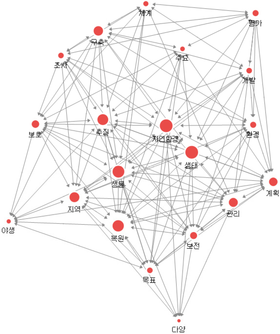
- Drawing on previously reported language-network analysis of major environmental policy plans and living-lab literature, this article reinterprets the need for living labs in environmental policy making through critical scale theory and Henri Lefebvre’s theory of the production of space. The original frequency and degree-centrality values are preserved without alteration, but they are re-read through four interpretive axes - problem definition, actor authorisation, knowledge formats, and evaluative temporality - as scalar signifiers. The analysis shows that environmental policy documents privilege a macro, technocratic, and managerial rationality organised around management, planning, system building, and evaluation, whereas living-lab literature foregrounds participation, co-design, experimentation, learning, and networks rooted in real-life settings. The article also links these axes to illustrative Jeju implementation contexts, including plastic-zero, reusable-cup, and delivery-container initiatives, to show how a mediating scale can be institutionally embedded. This contrast reveals not only a lack of participation but a deeper scalar mismatch across four dimensions: problem definition, actor authorisation, knowledge formats, and evaluative temporality. Building on critical geography, collaborative governance, and co-production scholarship, the article conceptualises living labs as a mediating scale and boundary infrastructure that translates between the abstract space of policy representation and the lived spaces of environmental practice. On this basis, it proposes a multi-scalar design framework consisting of scalar diagnosis, co-design, real-world experimentation, feedback and rescaling, and institutional embedding, alongside a hybrid evaluation scheme combining quantitative indicators with qualitative changes in trust, learning, discourse, and network formation. The article argues that environmental policy should not merely add participation at the margins, but redesign its scalar architecture so that everyday environmental knowledge can be systematically incorporated into policy formation.
- COLLAPSE
본 연구는 환경정책 수립 과정에서 리빙랩 도입의 필요성을 인문지리학의 비판적 스케일 이론과 르페브르(Henri Lefebvre)의 공간 생산 이론을 통해 재해석한다. 분석의 실증적 토대는 환경부의 「제2차·제3차 자연환경보전기본계획」, 제주특별자치도의 「제주도환경보전기본계획」과 「제2차 제주특별자치도 환경보전기본계획」, 그리고 국내외 리빙랩 문헌을 대상으로 수행된 언어네트워크 분석 결과에 두며, 본 논문은 기존 연구에서 제시된 빈도와 연결중심성 수치값을 수정하지 않고 유지한다. 대신 본 논문은 이 결과를 단순한 단어 비교가 아니라 문제정의, 행위자 승인, 지식 형식, 평가의 시간성이라는 네 가지 해석축 위에서 ‘스케일 표지(scalar signifiers)’의 배열로 재분류하여 읽는다. 이를 통해 환경정책 문헌이 ‘관리·계획·구축·체계·평가’라는 거시적·기술관료적 언어를 중심으로 정책의 추상공간을 생산하는 반면, 리빙랩 문헌은 ‘참여·협력·co-design·실험·학습·네트워크’라는 미시적·과정적 언어를 중심으로 생활세계의 차이공간을 전경화한다는 점을 논증한다. 또한 제주의 2040 PZI(플라스틱 제로 아일랜드), 1회용컵 보증금제, 배달 다회용기 시범사업과 같은 지역 실행 맥락을 보조적으로 연결하여 ‘매개 스케일’의 제도화 조건을 구체화한다. 이러한 대비는 환경정책이 단순히 참여가 부족한 것이 아니라, 문제정의의 스케일, 행위자 승인 방식, 지식 형식, 평가의 시간성에서 구조적인 스케일 불일치(scalar mismatch)를 내포하고 있음을 보여준다. 이에 따라 본 연구는 리빙랩을 주변적 참여 프로그램이 아니라 정책공간과 생활세계 사이를 번역하고 재조정하는 ‘매개 스케일(mediating scale)’이자 ‘경계 인프라(boundary infrastructure)’로 개념화한다. 나아가 스케일 진단 - 공동설계 - 현장실험 - 피드백과 재스케일링 - 제도화로 구성된 다중스케일 환경정책 설계 원리와, 정량지표와 함께 신뢰·학습·네트워크·담론 변화까지 포괄하는 복합 평가체계를 제안한다. 본 연구는 환경정책과 리빙랩 담론 사이의 간극을 인문지리적 언어로 정식화함으로써, 제주를 포함한 지역 환경거버넌스의 제도 설계에 이론적·실천적 시사점을 제공한다.
-
A Human Geographical Reflection on the Necessity of Multi-Scalar Environmental Policy
- Focusing on Scalar Mismatch between Environmental Policy Discourse and Living-Lab Discourse -
-
-
Effects of Short-Term Warming-Cooling Phases on Atmospheric PM10 Concentration Dynamics during the Winter-to-Spring Season
- A Case Study of Busan Metropolitan City -
겨울-봄철 단기 기온 증감 국면이 대기 미세먼지 농도 변화에 미치는 영향 - 부산광역시 사례 분석 -
-
Park, Sunyurp
박선엽
- Based on two decades (2006~2025) of daily observations in Busan, South Korea, this study investigates the time-series relationship between short-term temperature variation …
본 연구는 지난 20년간(2006~2025) 관측된 부산광역시 일별 미세먼지 농도 자료를 토대로 고농도 미세먼지가 발생하는 겨울~봄철(12~5월)의 단기 기온 변동성과 미세먼지 농도 간의 시계열적 …
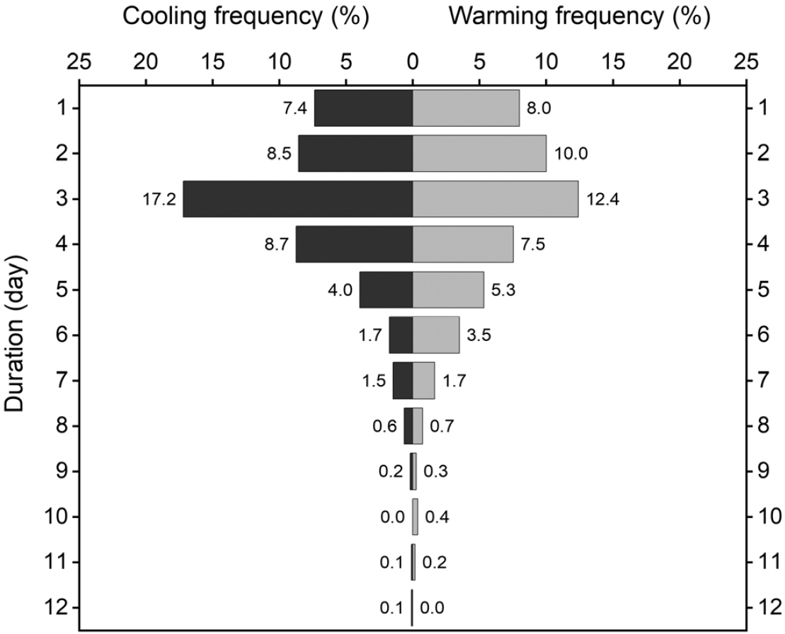
- Based on two decades (2006~2025) of daily observations in Busan, South Korea, this study investigates the time-series relationship between short-term temperature variation amplitude of air temperature and the fluctuations of atmospheric PM10 concentrations during the winter-spring season, when high PM10 episodes frequently occur. The results indicate that the rate of change, amplitude, and duration of warming and cooling episodes are key determinants of short-term variations in PM10 concentrations. While larger temperature change amplitudes intensify PM10 fluctuations, extended warming or cooling episodes diminish PM10 accumulation and scavenging effects, showing a negative correlation between temperature change amplitude and PM10 change rates. The correlation between temperature and PM10concentration fluctuations is found to be associated with the irregularity of recurring warming and cooling phases. Furthermore, this irregularity in temperature variability tends to increase at stations with higher annual temperature ranges. These findings suggest that geographical characteristics associated with maritime influences strengthen the local-level linkage between short-term temperature variability and PM10 concentration dynamics.
- COLLAPSE
본 연구는 지난 20년간(2006~2025) 관측된 부산광역시 일별 미세먼지 농도 자료를 토대로 고농도 미세먼지가 발생하는 겨울~봄철(12~5월)의 단기 기온 변동성과 미세먼지 농도 간의 시계열적 연관성을 분석하였다. 분석 결과에 따르면, 기온변화율, 변화 폭, 지속기간을 포함한 온난기와 한랭기의 속성은 미세먼지 농도의 단기 변화를 추동하는 영향 요인으로 작용하였다. 전반적으로 기온 변화 폭이 클수록 미세먼지 농도의 변화 폭도 증가한 반면, 기온 증감의 지속기간이 길어질수록 대기 물질의 축적이나 확산 효과가 점차 감쇄되어 기온 증감에 따른 농도 변화율은 오히려 감소하는 음의 상관관계를 나타냈다. 기온과 미세먼지 농도 변화 사이의 상관성은 반복되는 기온 증감 국면의 불규칙성과 관련된 것으로 분석되었다. 또한, 기온 변동의 불규칙성은 연교차가 높은 지점일수록 증가하는 경향을 보였고, 해양의 영향과 관련된 이러한 지리적 특성은 국지적으로 나타나는 기온-미세먼지 농도 변화 간 연관성을 강화하는 요인으로 작용함을 시사한다.
-
Effects of Short-Term Warming-Cooling Phases on Atmospheric PM10 Concentration Dynamics during the Winter-to-Spring Season
- A Case Study of Busan Metropolitan City -
-
-
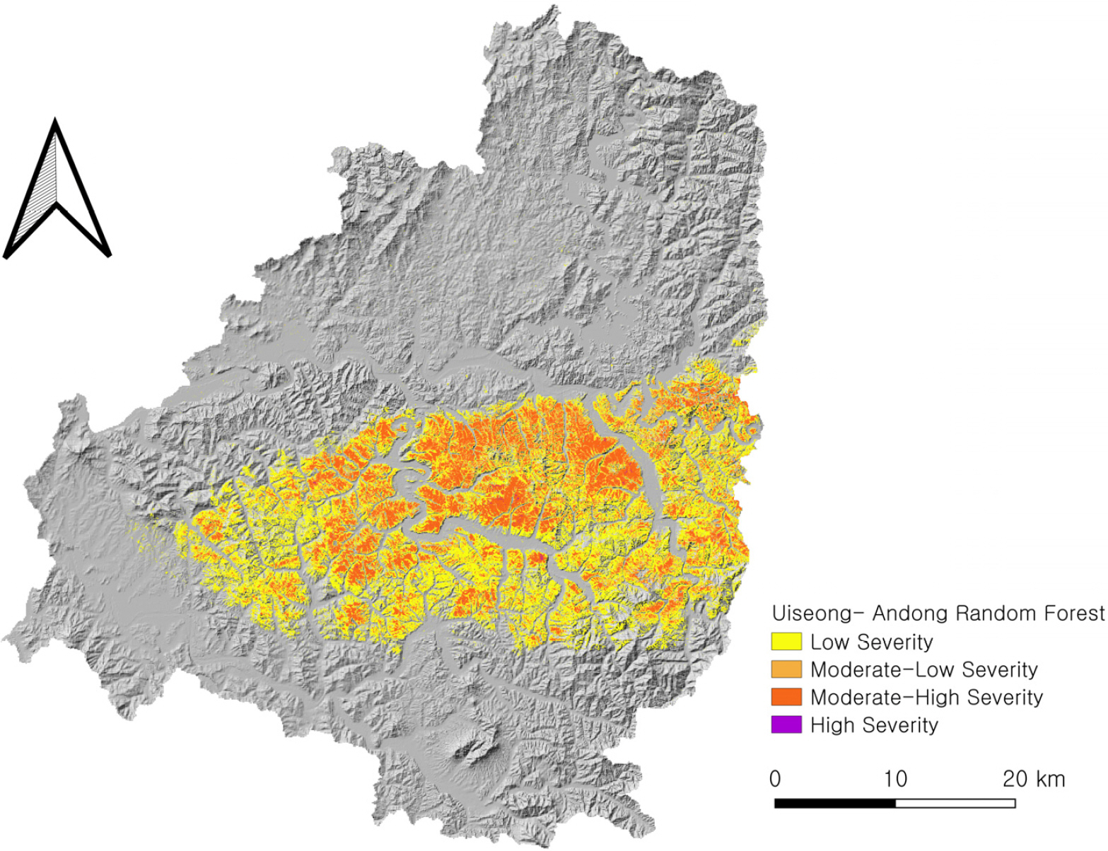
Comparative Analysis of the Effects of Topography and Forest Stand Characteristics on Burn Severity
- A Case Study of the Uiseong-Andong and Sancheong-Hadong Wildfires in 2025 -
지형 및 임상 조건이 산불 피해 강도에 미치는 영향 비교 - 2025년 의성-안동 및 산청-하동 산불을 대상으로 -
-
Park, Sang-uk · Sun, Minsung · Ha, Juyeon · Hong, Seongchan
박상욱 · 선민성 · 하주연 · 홍성찬
- This study compared the effects of topography and forest stand characteristics on burn severity in the 2025 Uiseong-Andong and Sancheong-Hadong wildfires. Using …
기후변화로 인해 대형화되는 산불의 피해를 저감하기 위해서는 지역별 환경 특성을 고려한 맞춤형 대응이 필수적이다. 본 연구는 2025년 발생한 의성-안동 및 산청-하동 산불을 …
- This study compared the effects of topography and forest stand characteristics on burn severity in the 2025 Uiseong-Andong and Sancheong-Hadong wildfires. Using Sentinel-2 satellite imagery (dNBR) and a Spatial Lag Model (SLM) to control for spatial dependence, we identified the pre-fire Normalized Difference Moisture Index (pre_NDMI) as the primary factor exacerbating damage in both regions, acting as a proxy for available fuel load. However, specific fire spread mechanisms varied significantly. In Uiseong-Andong, valley fuel accumulation intensified damage, whereas mature forests acted as firebreaks. Conversely, in Sancheong-Hadong, topographic dryness on south-facing slopes and broadleaf leaf litter significantly worsened fire severity. This quantitative analysis highlights the necessity for tailored, region-specific forest management policies that move beyond uniform standards.
- COLLAPSE
기후변화로 인해 대형화되는 산불의 피해를 저감하기 위해서는 지역별 환경 특성을 고려한 맞춤형 대응이 필수적이다. 본 연구는 2025년 발생한 의성-안동 및 산청-하동 산불을 대상으로, 위성 영상 기반의 정규화 연소 지수의 차(dNBR)를 종속 변수로 설정하고 공간시차모형(SLM)을 적용하여 지형 및 임상 요인이 산불 피해 강도에 미치는 영향을 비교 분석하였다. 분석 결과, 두 지역 모두 산불 전 식생 수분 지수가 산불 피해 강도를 높이는 가장 지배적인 공통 요인으로 확인되었으며, 이는 높은 수분 지수가 가용 연료 부하량(Fuel load)을 대변하기 때문으로 해석된다. 그러나 구체적인 확산 기작에서는 지역별로 뚜렷한 차이가 나타났다. 의성-안동 지역은 계곡부의 연료 밀집이 피해를 키운 반면, 수고가 높은 성숙림에서는 지표화의 수관화 전이가 억제되어 산불 확산을 방어하는 역할을 하였다. 산청-하동 지역은 일사량이 많은 남향 및 남서향 사면의 지형적 건조도와 급경사지에 분포한 활엽수림의 낙엽층이 결합하여 산불 피해를 가중시키는 핵심 요인으로 작용하였다. 본 연구는 원격 탐사 및 공간 통계 기법을 통해 지역별 산불 확산 메커니즘의 차이를 정량적으로 규명하였으며, 향후 일률적인 기준을 탈피한 지역 맞춤형 산림 관리 정책 수립을 위한 기초 자료를 제공한다는 데 의의가 있다.
-
Comparative Analysis of the Effects of Topography and Forest Stand Characteristics on Burn Severity
- A Case Study of the Uiseong-Andong and Sancheong-Hadong Wildfires in 2025 -
-
-
The European Union’s FOOD 2030 Policy and Food Systems Education
- Implications for Geography Education -
유럽의 FOOD 2030 정책과 식품 시스템 교육 - 지리교육의 역할과 방향 모색 -
-
Cho, Chul-Ki · Lee, Jong-Ho
조철기 · 이종호
- This study analyzes the EU’s FOOD 2030 food system transition policy and its educational instrument, the CLEVERFOOD project, and critically examines the …
본 연구는 EU의 식품 시스템 전환 정책인 FOOD 2030과 그 교육적 실천 수단인 CLEVERFOOD 프로젝트의 주요 내용을 분석하고, 이를 토대로 한국 지리교육에서 …
- This study analyzes the EU’s FOOD 2030 food system transition policy and its educational instrument, the CLEVERFOOD project, and critically examines the implications for food systems education within Korean geography education. The analysis reveals that FOOD 2030 positions food as a social resource inseparably connected to health, climate, and community development, and pursues structural transformation across the entire food cycle—from production through disposal—in conjunction with the Farm to Fork Strategy. CLEVERFOOD integrates social mobilization and educational practice for this transition through three operational axes: Policy Labs, Living Labs, and Pan-European Multi-Actor and Public Engagement. This EU experience demonstrates that the paradigm of food education is shifting from an individual health focus toward a critical understanding of global food value chains. The study argues that the spatial disjuncture between production and consumption, power relations within global food value chains, and the geographical implications of local food movements can be reconstituted as core content in geography education, and that cultivating food citizenship constitutes a practical imperative for the discipline.
- COLLAPSE
본 연구는 EU의 식품 시스템 전환 정책인 FOOD 2030과 그 교육적 실천 수단인 CLEVERFOOD 프로젝트의 주요 내용을 분석하고, 이를 토대로 한국 지리교육에서 식품 시스템 교육이 나아갈 방향을 비판적으로 검토한다. FOOD 2030은 식품을 건강·기후·지역사회 발전과 불가분하게 연결된 사회적 자원으로 규정하고, 농장에서 식탁까지 전략(Farm to Fork Strategy)과 연계하여 생산·가공·유통·소비·폐기 전 과정의 구조적 전환을 목표로 한다. CLEVERFOOD는 정책랩, 리빙랩, 범유럽 다자간 이해관계자 참여라는 세 축을 통해 이러한 전환을 위한 사회적 동원과 교육적 실천을 결합한다. 이 같은 EU의 경험은 식품 교육의 패러다임이 개인 건강 중심에서 글로벌 식품 가치사슬에 대한 비판적 이해로 이행하고 있음을 보여준다. 본 연구는 생산지와 소비지의 공간적 불일치, 식품 가치사슬의 권력관계, 로컬푸드 운동의 지리적 함의 등이 지리 교과의 핵심 내용으로 재구성될 수 있으며, 식품 시민성 함양이 지리교육의 실천적 과제임을 제시한다.
-
The European Union’s FOOD 2030 Policy and Food Systems Education
- Implications for Geography Education -

 REGION AND GEOGRAPHY
한국지역지리학회
경상남도 진주시 진주대로 501 경상국립대학교 사범대학 지리교육과
Tel: 055-772-2180 / Fax: 055-772-2189 / E-mail: admin@krg.or.kr Copyright© The Korean Association of Regional Geographers. Powered by APUB
Tel: 055-772-2180 / Fax: 055-772-2189 / E-mail: admin@krg.or.kr Copyright© The Korean Association of Regional Geographers. Powered by APUB